Friday, December 13, 2013

Stokesay Castle - To Protect Against the Marauding Welsh

Stokesay Castle is one of my favorite castles in the United Kingdom.  It is also the smallest.  Its remarkable preservation is what makes this jewel special.  The castle, which is actually a heavily fortified manor house sits near the Welsh border in western Shropshire.  The valley where it is situated was one the major thoroughfares across the Welsh Marches were bands of Welsh sometimes crossed the border to prey on English farms and manors.

The castle complex now consists of a tower keep, a great hall, a curtain wall that surrounds about one acre and a curious Tudor style gate house that was added in the 1600s.  Unfortunately, several small out buildings within the curtain walls have been lost to time.  Stone foundations in the soil mark where they once stood.  The level of preservation of this remarkable place is for two reasons.  First is the poverty that owners endured in the years after the Civil War.  That lack of funds did not allow remodeling or changes that occurred in more affluent manors through the years.  The second is the foresight of the Allcroft family who purchased Stokesay in 1896.  They took enormous care to restore and preserve the castle in its original form, although the retained the gate house and other additions that date from Tudor times.


Stokesay Castle is really a 13th Century fortified manor house.  The tower was constructed in 1240 by the de Say family.  The tower was built in a village known as South Stoke. This was later added to the family name - Stoke-de-Say.  It was a wild and lawless time on the border in those years hence the need for the tower and a small moat around the whole village.  Work on a Norman church was also began at the same time. 
From: Castles From the Air: An Aerial Portrait of Britain's Finest Castles.
 
The following is from the English Heritage web site for Stokesay Castle.  More information and additional photographs can be found there. 

http://www.english-heritage.org.uk/daysout/properties/stokesay-castle/

Stokesay Castle is quite simply the finest and best preserved fortified medieval manor house in England. Set in peaceful countryside near the Welsh border, the castle, timber-framed gatehouse and parish church form an unforgettably picturesque group.


Lawrence of Ludlow purchased the property in 1291 and began to fortify the manor in earnest.  He added a great hall, and received permission from Edward I to crenelate (build curtain walls).  The curtain wall enclosed the courtyard and rose 30 feet above the moat. During the Civil War, Parliamentarian Forces captured the castle and destroyed the defensive crenelations on the wall.) Lawrence of Ludlow's family lived at Stokelay for 300 years. This illustration from the English Heritage web site shows how Stokesay may have looked during Lawrence of Ludlow's time.
Lawrence of Ludlow, a wealthy local wool-merchant wishing to set up as a country gentleman, bought the property in 1281, when the long Anglo-Welsh wars were ending. So it was safe to raise here one of the first fortified manor houses in England, 'builded like a castle' for effect but lit by large domestic-style windows. Extensive recent tree-ring dating confirms that Lawrence had completed virtually all of the still surviving house by 1291, using the same team of carpenters throughout: more remarkably, the dating also revealed that it has scarcely been altered since.


The stone stairway in the 60 foot tower is unusual in that it wind down clockwise instead of counterclockwise.  Most are done in the opposite manner so a right handed defender can more easily wield his sword. Photo by author.


An arrow slit defends the moat with a view west to the Welsh border.  Photo by author
 
Stokesay's magnificent open hearthed great hall displays a fine timber roof, shuttered gable windows and a precipitous staircase, its treads cut from whole tree-trunks. It is flanked by the north tower, with an original medieval tiled floor and remains of wall painting, and a 'solar' or private apartment block, and beyond this the tall south tower - the most castle-like part of the house, self-contained and reached by a defensible stairway.


The Great Hall adjacent to the Tower Keep.  The hall was were most manor business was conducted, meal taken, guests lodged and where servants slept.  It has been alter little since it was built in 1291.  As is normal for that time frame, there is not fireplace or hearth.  An open fire was usually built on the floor in the middle of the hall.  Large Gothic windows open to the courtyard to let in light. Photo by author.

Inside the Great Hall.  The oak timber rafters are original as is most of the slate roofing. Photo by author.


View from inside the Great Hall across the courtyard to the Gate House.
The door still has its giant iron reinforced oaken door.
Photo from: http://www.english-heritage.org.uk/daysout/properties/stokesay-castle/

An opposite view across the Great Hall to the stairs to the living quarters.   Photo from: http://www.english-heritage.org.uk/daysout/properties/stokesay-castle/

The solar block contains one of the few post-medieval alterations to the house, a fine panelled chamber. Its dominating feature is a fireplace with a richly carved overmantel, still bearing the traces of original painting in five colours. This was added in about 1641, at the same time as the truly delightful gatehouse: an example of the Marches style of lavishly showy timber-framing, bedecked with charming carvings of Adam and Eve.


The Solar.  This room is in between the Great Hall and the Tower.  This is where the Lady of the manor and her hand maids would have spent their time, sewing, embroidering and gossipping.  These type room were called solars because they normally provided good light through large windows. Photo from: http://www.english-heritage.org.uk/daysout/properties/stokesay-castle/
This Amazing carved mantle was added to the solar during upgrades to the living quarters in the 17th Century. 
Photo by author.

 
Before the 17th Century additions, a smaller defense tower was positioned at the south end of the Great Hall.  In the 1640s it was converted to living quarters.  The top of the tower did not offer enough floor space, so these added apartments seem to hang from the side of the structure.  Photo by author.
 
The Gate House entrance to Stokesay was added along with other improvements in the 17th Century.  It seem out of place next to the 13th Century buildings, but adds a unique charm.  Photo by author.
The 17th Century Gate House from the top of the Tower. Photo by author.
 
One of the many 17th Century wood carvings that still decorate the Gate House.  Photo by author
A few years later, in 1645 Stokesay experienced its only known military encounter, surrendering without fighting to a Parliamentarian force. So the house remained undamaged, and sensitive conservation by Victorian owners and English Heritage have left it the medieval jewel which survives today.
 
No visit to any English Heritage site is complete without a spot of tea, and a scone, jam and clotted cream!


Tuesday, November 26, 2013

My Sorrow Knows No Limit


In 2000 a unique archaeological find in Andong City Korean captured the imagination of the Korean people.  The archaeological site was a tomb with a remarkably preserved mummy.  At 5 foot 9 inches he was tall for his people, especially in his day.  His dark hair and dark mustache were still intact.  Eung-Tae died in 1586, four hundred and twenty seven years ago.


Archaeologists in Andong City, South Korea, unwrap cloth covering the
16th-century mummy of Eung-tae, a member of Korea's ancient Goseong Yi clan.
  http://archive.archaeology.org/1003/abstracts/korea.html
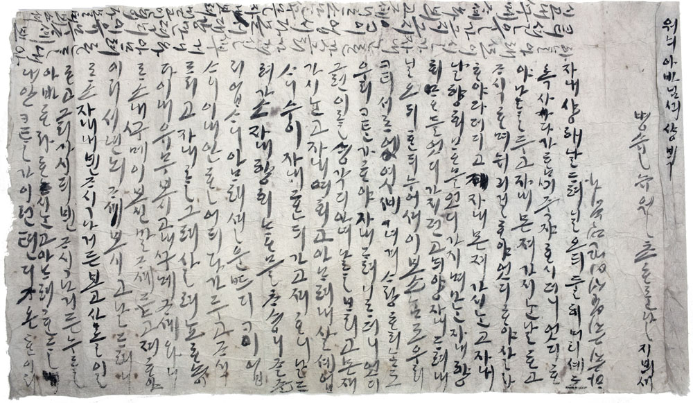
A well preserved mummy is a rare find in Korea, but what was found with him is what has captivated the imagination of the Korean people.  Thirteen letters and notes addressed to Eung-Tae were found with him in his tomb, all written by his pregnant wife whose identity had been lost.

These poignant notes remind us that the human heart is timeless.  It knows no cultural, geographical or generational bounds.  The emotions that this young wife pours from her heart into her eulogies remind us that our ancestors and the people who lived in the past did so with real heart and real emotion.  They were not simply characters in a history book.  
One note was found on a paper bundle containing a pair of sandals woven from the grieving  widow's hair.  She wrote: “with my hair I weave this” and “before you were even able to wear it.”


The sandals woven from Eung-Tae's bride from her own hair
http://web2.uconn.edu/strawsandals/?p=372


Of all the notes left to Eung-Tae, the one lovingly laid upon his chest is the one most remembered.   The translation to English from archaic Korean has diminished the poetry that was once in the lines, but the love and loss is still very clear.


To Won's Father

June 1, 1586

You always said, "Dear, let's live together until our hair turns gray and die on the same day." How could you pass away without me? Who should I and our little boy listen to and how should we live? How could you go ahead of me?

How did you bring your heart to me and how did I bring my heart to you? Whenever we lay down together you always told me, "Dear, do other people cherish and love each other like we do? Are they really like us?" How could you leave all that behind and go ahead of me?

I just cannot live without you. I just want to go to you. Please take me to where you are. My feelings toward you I cannot forget in this world and my sorrow knows no limit. Where would I put my heart in now and how can I live with the child missing you?

Please look at this letter and tell me in detail in my dreams. Because I want to listen to your saying in detail in my dreams I write this letter and put it in. Look closely and talk to me.

When I give birth to the child in me, who should it call father? Can anyone fathom how I feel? There is no tragedy like this under the sky.

You are just in another place, and not in such a deep grief as I am. There is no limit and end to my sorrows that I write roughly. Please look closely at this letter and come to me in my dreams and show yourself in detail and tell me. I believe I can see you in my dreams. Come to me secretly and show yourself. There is no limit to what I want to say and I stop here.


A photo of the love letter to Eung-Tae.  From: http://archive.archaeology.org/1003/abstracts/korea.html


Friday, November 8, 2013

America's Largest Mass Grave


This story is a bit of a departure from my usual postings.  Hart Island is not an archaeological site and not a tourist destination. (Although it has the potential to become both someday.)  It is a historic site on many levels, but it is not appreciated or interpreted as such.  I had never heard of Hart Island, and evidently that is true even for most New Yorkers.  "Mass Grave" may be an overstatement as each burial was in individual coffins.  However, the graves are dug in "mass" fashion with long trenches to hold hundreds of bodies at a time.  I find this story fascinating and re-blog it in its entirety below.

What We Found at Hart Island, The Largest Mass Grave Site in the U.S.
 
By - Kelsey Campbell-Dollaghan, November 7, 2013

It’s a place where few living New Yorkers have ever set foot, but nearly a million dead ones reside: Hart Island, the United States’ largest mass grave, which has been closed to the public for 35 years. It is difficult to visit and off-limits to photographers. But that may be about to change, as a debate roils over the city’s treatment of the unclaimed dead. Never heard of Hart? You’re not alone—and that’s part of the problem.

 
Hart Island is a thin, half-mile long blip of land at the yawning mouth of Long Island Sound, just across the water from City Island in the Bronx. Depending on who you ask, it was named either for its organ-like shape or for the deer (or hart) that thrived here after trekking across the frozen sound in the 18th century. Hart is dense with history; it’s been used as a prison for Confederate soldiers, a workhouse for the poor, a women's asylum, and a Nike missile base during the Cold War.


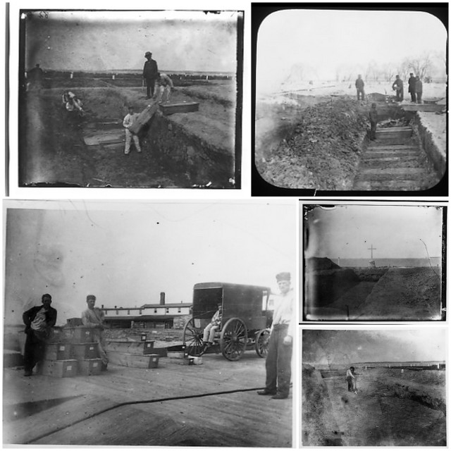
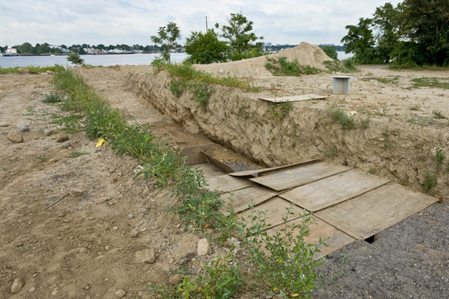
Its most important role has been to serve as what’s known as a potter’s field, a common gravesite for the city’s unknown dead. Some 900,000 New Yorkers (or adopted New Yorkers) are buried here; hauntingly, the majority are interred by prisoners from Riker’s Island who earn 50 cents an hour digging gravesites and stacking simple wooden boxes in groups of 150 adults and 1,000 infants. These inmates—most of them very young, serving out short sentences—are responsible for building the only memorials on Hart Island: Handmade crosses made of twigs and small offerings of fruit and candy left behind when a grave is finished.


There are a few ways to end up on Hart Island. One third of its inhabitants are infants—some parents couldn’t afford a burial, others didn’t realize what a “city burial” meant when they checked it on the form. Many of the dead here were homeless, while others were simply unclaimed; if your body remains at the city morgue for more than two weeks, you, too, will be sent for burial by a team of prisoners on Hart Island. These practices have given rise to dozens of cases where parents and families aren’t notified in time to claim the body of their loved one. It can take months (even years) to determine whether your missing mom, dad, sibling, or child ended up at Hart.
Even if you do learn that a friend or loved one is buried at Hart, you won’t be able to find out exactly where. Though Hart Island is the largest publicly funded cemetery in the world, it’s been closed to the public since 1976, when the Department of Corrections took control of the site. Family members can request a visit on the last Thursday of every month, but they aren’t allowed to visit specific graves—in fact, there’s no official map (not to mention burial markers) of the mass graves on Hart. The Hart Island Project, a nonprofit organization led by an artist named Melinda Hunt, is spearheading the fight to change that: Hunt has worked for decades to convince the city to transfer control of the island from the DOC to the Parks Department, making it into a public cemetery in name, as well as in function.

 Hunt got involved with Hart during the 1980s, when the AIDS epidemic put the island into the public spotlight for the first time (the first New York child to die of the virus is buried here in the only individual grave on the island). Her book about the island was published in 1998, and represents the last time an artist was allowed to work on-site. Since then, Hunt has single-handedly acted as the sole legal and political advocate for families of the deceased buried here, and in the process, become the foremost historian and keeper of knowledge about the island.
 
Image copyright Joel Sternfeld and Melinda Hunt. From their 1998 book, Hart Island.
Part of her self-assigned job is to liaise with family members searching for information about their loved ones—like Elaine Joseph, a lifetime New Yorker and veteran who now serves as Secretary of the Hart Island Project. It’s taken Joseph more than 30 years to find out that her child was buried on the island—not an unusual scenario, it turns out, though no less heartbreaking. It’s women like Joseph, who have come forward to tell their stories, who are helping Hunt to raise awareness of the gross mishandling of Hart Island.
On a dreary, lukewarm morning last month, Gizmodo—myself and co-worker Leslie Horn—along with two other reporters, met Hunt and Joseph in the quaint town of City Island. They had graciously offered to include us on a tour of the island, and we were about to become some of the first members of the press to visit since the 1980s.

 Because inmates perform weekly burials on Hart Island, the DOC treats outside visitors with a certain amount of caution. The two polite employees we met on the rundown dock at City Island asked first for our IDs, then for any electronics we had, storing our phones, tablets, and laptops in manila folders inside a DOC trailer on the dock, where we also used the restroom (there are none on the island). Inside the stall, someone had taped up a picture of a manatee—a reference to this meme—with the following mantra: Everything will be OK.


Hart Island photographs by Jacob Riis via The Hart Island Project
 
After everyone was ready, we boarded a small ferry and chugged off into the fog. To overly-dramatic loons like me, stepping aboard felt like crossing the River Styx or sailing out to Arnold Böcklin’s Isle of the Dead—except, in this scenario, the gatekeepers were clad in NYC corrections uniforms. As Joseph recounted her story, and our ferry slogged across the channel, it became clear that, for the loved ones of people buried here, the fight for Hart Island isn’t about entering an underworld—it’s about seeking the right to mend ties with the living.

35 years ago, Joseph gave birth to a baby girl who needed surgery a few days later. The operation took place at Mount Sinai Hospital during the Great Blizzard of 1978, which shut down the city’s roads and phone lines for days. When a recovering Joseph got through to the hospital, she learned that her baby had died during surgery. Eventually, she was connected with the understaffed city morgue—which informed her that her child had already been buried with other infants. When the death certificate finally arrived, no cemetery was listed.

In city parlance, a blank spot next to the cemetery means one thing: A Hart Island burial. But, in a time before the internet, that fact was lost on anyone without inside knowledge—and Joseph spent the next decade trying to find out where her daughter was buried, visiting the Medical Examiner’s office and digging through the municipal archives. It was as if her child had never been born. “It came to a standstill,” she says, speaking over the phone later. “Over the years, I went on with life.” But every so often, she’d try again—fruitlessly searching the city’s archives for a trace.

 It was only in 2008, 31 years after she gave birth, that Joseph’s first lead emerged—thanks to the internet. A Google search for “potter’s field” returned a mention of Hart Island, and then, the Hart Island project—headed up by one Melinda Hunt. She sent her an email. A few months later, after a Freedom of Information request granted them access to burial records, the duo made a heartbreaking discovery: Two volumes of infant burial records, spanning 1977 to 1981, were missing. The lead had gone cold.


Grave of first child to die of AIDS in NYC, with burial documents. Photo by Melinda Hunt via The Hart Island Project
What’s perhaps even more painful about city burials is that the relatives whose loved ones are buried on the island—thousands of the living—can’t freely visit it. Instead, they must request a visit formally from the Department of Corrections, which will usually grant the right to visit a small gazebo near the dock, rather than any of the actual burial sites. Our tour was Joseph’s second time on the island, and she visibly fumed about being forced to sign into a DOC visitor’s book as we disembarked.

 It’s a grim scene: A trash-covered shoreline gives way to scrubby brown grass and a gravel driveway, where two rusting vans are parked beside a handful of officers waiting to check our IDs. The only sign of the island’s purpose are several tiny white angel statues that line the rotting pathway around a nondescript garage building. The cherubs seem like new additions, judging by the tags still visible on their behinds.
The two DOC guides flanked our small group closely on either side, guiding us along the shore. Our “tour” of the island was, in a sense, over even before it began: The final destination is less than 20 yards from the dock, where a small wooden gazebo—someone in the group calls it a “chicken coop”—gives shelter to mourners who visit the island. The DOC’s regulations prevent us from walking further into the patchy grass that covers the island, so we sit down on the benches inside the hut.

A few feet away, a small gravestone represents the only sign of a burial memorial. The stone was paid for by the family of the island’s long-time backhoe operator when he passed away. Behind it, a Victorian-era administrative building, likely left over from the island’s one-time psychiatric hospital, lies in ruins. Any real grave markers that remained were removed years ago by the DOC; today, Hart looks like a dreary but nondescript spit of land you might find anywhere else along the mid-Atlantic.

 
An open burial pit next to the wards in the west of the island. Source: Kingston Lounge

Hunt and Joseph pull out a pen-marked map (pieced together by Hunt using satellite imagery) and try to locate the general direction of where her daughter—along with many other misplaced infants from the same year—might lie. It’s woefully inadequate, not to mention unnecessary given the advent of GPS. Even if the DOC doesn’t create markers for each gravesite, they could certainly make the information available online. But Hart—right down to its decaying Victorian buildings—is stuck in the past. As Hunt explains, much of the way Hart operates dates from the Civil War. “This is a very 19th century kind of place,” she adds.
But it doesn’t have to be. Hunt, who qualifies as nothing short of a hero, is working to extract answers to painful questions—not only at the personal level, but at a legal one. Do loved ones have a legal right to visit a family gravesite? In some states—mostly in the South, where Civil War graves often lie on private land—yes. But, in New York, things are more ambiguous: State public health laws codify the common law right to a decent burial, but it is unclear whether that includes the right to visitation. In 2012, a New York Ob/Gyn named Dr. Laurie Grant, whose stillborn daughter was buried on Hart Island without her consent in 1993, brought a lawsuit in New York State Court seeking an injunction against the DOC that would allow her to visit the gravesite.

 Thanks to years of testimony by Hunt, things are slowly changing on the city side of things: In April, the DOC set up an online database of burial records. And in September, Hunt tweeted that the DOC would grant access to GPS information, too. Just this week, a request to visit grave sites made by Joseph and seven other women received a response that promised their petition is being considered.
After all, the Department of Corrections isn’t to blame, since it’s their job to run prisons—and they do this well—but prison guards simply aren’t a good match for running a massive cemetery. The next big push will be a bill first introduced last year, which would mandate the Department of Parks to assume control of the island. A big part of getting the bill off the ground—and mothers like Grant and Joseph to their children's graves—is rousing public awareness and support. In many cases, New Yorkers just haven't heard about what's going on at Hart.

 What’s most curious about the situation, in some ways, isn’t whether the city will eventually open up Hart Island to the public—that seems all but inevitable—but what will happen to the island afterward. Hunt’s hope, which she described in a New York Times op-ed last month, is that the island will become the city’s next public park and memorial to the city’s past inhabitants. “I like to think of Hart Island as New York City’s family tomb,” she wrote. “We don’t always get along, but we do live and die and are buried close to one another.” Joseph, for her part, would just be happy with grave markers. “I have nothing to lose by continuing to fight for these rights,” she added as we left the island last month. Today, she’s hoping that Bill de Blasio’s election as mayor will speed up the process.

 
One of the mass graves that fit up to 150 adult coffins. Source: Kingston Lounge
The big question, of course, is why? Why hasn’t the city taken over control of the island? Why hasn’t anyone attempted to make it easier for families to visit? Where is the harm or danger in letting people mourn near where their loved ones lie? Tragically, the answer is similar to the reason people end up at Hart Island in the first place: A mixed bag of budgetary issues and pure practicality, wrapped up in a painful and banal truth. In a city of eight million, some things—whether people or whole islands—slip by unnoticed.

Another excellent website about Hart Island can be found here:  http://untappedcities.com/2013/07/22/abandoned-hart-island-new-york-citys-mass-burial-ground/


Thursday, October 24, 2013

Know Ye Not Agincourt?

Agincourt, Agincourt!
Know ye not Agincourt?
Never to be forgot
Or known to no men?
Where English cloth-yard arrows
Kill'd the French like tame sparrows,
Slaine by our bowmen
                                              Bowman's Glory. c. 1600


Until the year 1415, October 25th was known only for the Feast of Saint Crispin and Saint Crispinian.  The significance of those saints was lost among most, because every day was a feast day for one saint or another.  After 1415, the day would be celebrated as the greatest victory in English history.  In France it was mourned as the day that the flower of French nobility was lost on the killing fields of Agincourt. 

 Many histories of the Battle of Agincourt have been written, indeed the writing started almost as the battle closed.  It is one of the best documented medieval battles.  I won't try to recount the struggle here but will provide a very brief synopsis so the reader can understand the significance of the English victory and the extent of the devastation to the elite of French nobility.

 After a long and bitter siege of the port town of Harfleur, King Henry V of England marched his Army overland from Harfleur to Calais on the northern coast of France.  It should have been an eight day march.  Rations and supplies for only eight days were taken by the 1,000 men-at-arms and 5,000 archers of Henry's little army.  Two days from Calais his men were blocked from crossing the River Somme.  With his food supply running out he was forced to turn east, away from Calais to find an unprotected crossing point on the river.  Each bridge and ford were blocked by the enemy.  Finally the English, already four days overdue in Calais and long out of food were able to find a unguarded ford on the Somme.  A foot race on the Calais Road ensued between the weary, starving English army and a French force of almost 30,000 men. 

 The French outpaced the English and blocked the Calais Road near a little village called Agincourt.  In the battle on October 25th, Henry V's bedraggled men crushed the French Army and killed almost 8,000 French men-at-arms and knights, more men than in the entire English army.  English casualties were estimated to be only a few hundred.  Much of the victory can be attributed to the English archers and their deadly long bows.  Most who were there that day felt that only divine providence could have provided such an complete and lopsided victory. 

 My newest book, The Archer's Son, tells the story of a lad who goes along with a company of Cornish archers on the Agincourt Campaign.  The story follows the retinue of Sir John Trelawny from the Cornish village of Altarnon, to the Siege of Harfleur in France, the march to Calais and the Battle of Agincourt.  The experiences of this young boy change him forever.  Not just from the horrors of combat, but from the lasting brotherhood-of-arms that all soldiers, in all eras, develop with the men with which they serve. 

 Here is a snippet from Chapter 23 at the opening of the Battle of Agincourt:


"Keep your heads lads and nock a bodkin," William called out.  "There is Lord Erpingham.  Now we will provoke the French into moving."  The old knight strode quickly out in the field in front of the line where all could see him.  He tossed a baton high in the air to draw the attention of all the archers. 
"Now strike!"  The old knight bellowed at the top of his lungs.
In unison, five thousand archers muscled bow cords to their ears and launched arrows high in the air towards the French lines.  It was a long shot, so the high arching arrows took several seconds to ascend before they started their deadly fall to earth.  Hedyn could see a faint shadow that drifted across the wheat field created by the mass of five thousand feathered missiles.  Like a great flock of starlings, he thought. 
Before the first arrows began to thud into men and horses and to clang against armor, the archers were sending more arrows on their way, each man shooting at his own pace.  Within a minute 60,000 arrows were in the air or scattered across the battlefield.  Some in dirt, some in men.

 
Thirteen year old Hedyn, my protagonist, survives the battle.  But Agincourt is forever with him.  Our modern soldier's plague of post traumatic stress syndrome (PTSD) is not a new phenomena.  It has tormented soldiers since there have been wars.  We have only now began to understand and diagnosis it.  From the Epilogue to The Archer's Son comes this passage:

            For many months after his return, Hedyn seldom smiled or shared mirth with family or friends.  He somehow thought that happiness was disloyal to the grief that he felt for Roger, and Lawrence and other lost friends who were in lonely, anonymous graves at Harfleur.  Only through prayer did his sadness finally subside.  Christ brought him the understanding that his duty was to the living, and not to the dead.
            But he never shook the demons that came to him in his sleep.  Each night was a dreamy torment of charging black nights, clouds of arrows, blood and lifeless bodies.  Only his bride knew of his suffering.  The ivory handle dagger remained hidden under his sleeping matt.  It seemed the only thing to bring him at least a tiny bit of refuge from his dread of the night.  Even as an old man, fifty years after Agincourt, the dreams sometimes came to torture him. . .
            In later life, small boys would sometimes shyly approach the gray haired old man and ask, "Hedyn Archerson, you were there?  You were with Henry at Agincourt?"  They would puff themselves up and try to appear older as they clutched their little bows. 
            He would sigh and respond, "Aye.  I was there.  I was at Agincourt."  But he told only stories that made him laugh or made him happy or brought him pride.  He told no tales that brought him sadness. 

 
The Archer's Son will go to the editor in November and be released in mid 2014. 


The Author dressed as an English Archer at the time of Agincourt.  These photos were taken at "Days of Knights" a medieval living history program.  They will be used to help develop art work for The Archer's Son. Photos by the Author and Scott Lyndon.


A fully armored knight as they would have appeared at Agincourt.  The armor of the English and French was essentially the same.  The colorful surcoats gave the identity (and nationality) of the knight.


A young page assists his lord in donning his armor


An archer takes aim with his longbow


Thursday, October 10, 2013

The Boy in the Shadows


I’ve been asked by several readers how my publisher was able to capture the photograph on the cover of The Secret of Wattensaw Bayou.  They are surprised when I tell them that the photo was taken in my backyard!  Well, sorta taken in my backyard. 
Photoshop is an amazing tool.  The background photo of the swampy red sunset was purchased from an on line image seller.  The front image is a combination of computer magic and household devices.  I dressed the model in 19th century clothing and then put him in front of my back porch light.  My wife, Phyllis, then trained a red colored spot light on the young man from out of the frame.  The photo, taken from the model’s back in low light, resulted in a nice red tinted out-line around his silhouette.  He was then “lifted” from the photo frame and layered on top of the swamp photo. 

Who is the model?  Meet seventeen year old Jalen Lanier.  Jalen was sixteen when he posed for the book cover. He is the son of a co-worker and was happy to play the part of Ephraim Wright, the main character of The Secret of Wattensaw Bayou, for the book cover.  Jalen is a fine young man and I enjoyed working with him on two photo shoots to get the light just right on this shot.  I appreciate his help and patience immensely!


I’ll be using a similar technique for my next book, The Archer’s Son.  I already have a gorgeous background photo of a European Castle at sunset.  A photographer in Russia has graciously given me permission to use his work.  Now, who will be my young archer?


Monday, October 7, 2013

Lost in the Desert - For 2,500 Years!

I'm sorry for the long time since my last post.  I've been pre-occupied with completing the manuscript for my next novel.  I'm happy to report that I have finished The Archer's Son and hope to have it to my publisher in Novmeber to prepare it for a 2014 release. 

I recently stumbled across this interesting story.  It is from 2012, but has not been widely announced.  You can see additional photos at the website below. 
 

Vanished Persian Army Said Found in Desert

//

The remains of a mighty Persian army said to have drowned in the sands of the western Egyptian desert 2,500 years ago might have been finally located, solving one of archaeology's biggest outstanding mysteries, according to Italian researchers.
Bronze weapons, a silver bracelet, an earring and hundreds of human bones found in the vast desolate wilderness of the Sahara desert have raised hopes of finally finding the lost army of Persian King Cambyses II. The 50,000 warriors were said to be buried by a cataclysmic sandstorm in 525 B.C.
"We have found the first archaeological evidence of a story reported by the Greek historian Herodotus," Dario Del Bufalo, a member of the expedition from the University of Lecce, told Discovery News.

 
All photos from: 
http://news.discovery.com/history/archaeology/cambyses-army-remains-sahara.htm
According to Herodotus (484-425 B.C.), Cambyses, the son of Cyrus the Great, sent 50,000 soldiers from Thebes to attack the Oasis of Siwa and destroy the oracle at the Temple of Amun after the priests there refused to legitimize his claim to Egypt.
After walking for seven days in the desert, the army got to an "oasis," which historians believe was El-Kharga. After they left, they were never seen again.
"A wind arose from the south, strong and deadly, bringing with it vast columns of whirling sand, which entirely covered up the troops and caused them wholly to disappear," wrote Herodotus.

A century after Herodotus wrote his account, Alexander the Great made his own pilgrimage to the oracle of Amun, and in 332 B.C. he won the oracle's confirmation that he was the divine son of Zeus, the Greek god equated with Amun.
The tale of Cambyses' lost army, however, faded into antiquity. As no trace of the hapless warriors was ever found, scholars began to dismiss the story as a fanciful tale.

Now, two top Italian archaeologists claim to have found striking evidence that the Persian army was indeed swallowed in a sandstorm. Twin brothers Angelo and Alfredo Castiglioni are already famous for their discovery 20 years ago of the ancient Egyptian "city of gold" Berenike Panchrysos.
Presented recently at the archaeological film festival of Rovereto, the discovery is the result of 13 years of research and five expeditions to the desert.

"It all started in 1996, during an expedition aimed at investigating the presence of iron meteorites near Bahrin, one small oasis not far from Siwa," Alfredo Castiglioni, director of the Eastern Desert Research Center (CeRDO)in Varese, told Discovery News.
While working in the area, the researchers noticed a half-buried pot and some human remains. Then the brothers spotted something really intriguing -- what could have been a natural shelter.

It was a rock about 35 meters (114.8 feet) long, 1.8 meters (5.9 feet) in height and 3 meters (9.8 feet) deep. Such natural formations occur in the desert, but this large rock was the only one in a large area.
"Its size and shape made it the perfect refuge in a sandstorm," Castiglioni said.

Right there, the metal detector of Egyptian geologist Aly Barakat of Cairo University located relics of ancient warfare: a bronze dagger and several arrow tips.


"We are talking of small items, but they are extremely important as they are the first Achaemenid objects, thus dating to Cambyses' time, which have emerged from the desert sands in a location quite close to Siwa," Castiglioni said.

About a quarter mile from the natural shelter, the Castiglioni team found a silver bracelet, an earring and few spheres which were likely part of a necklace.
"An analysis of the earring, based on photographs, indicate that it certainly dates to the Achaemenid period. Both the earring and the spheres appear to be made of silver. Indeed a very similar earring, dating to the fifth century B.C., has been found in a dig in Turkey," Andrea Cagnetti, a leading expert of ancient jewelry, told Discovery News.

In the following years, the Castiglioni brothers studied ancient maps and came to the conclusion that Cambyses' army did not take the widely believed caravan route via the Dakhla Oasis and Farafra Oasis.

"Since the 19th century, many archaeologists and explorers have searched for the lost army along that route. They found nothing. We hypothesized a different itinerary, coming from south. Indeed we found that such a route already existed in the 18th Dynasty," Castiglioni said.
According to Castiglioni, from El Kargha the army took a westerly route to Gilf El Kebir, passing through the Wadi Abd el Melik, then headed north toward Siwa.

"This route had the advantage of taking the enemy aback. Moreover, the army could march undisturbed. On the contrary, since the oasis on the other route were controlled by the Egyptians, the army would have had to fight at each oasis," Castiglioni said.
To test their hypothesis, the Castiglioni brothers did geological surveys along that alternative route. They found desiccated water sources and artificial wells made of hundreds of water pots buried in the sand. Such water sources could have made a march in the desert possible.

"Termoluminescence has dated the pottery to 2,500 years ago, which is in line with Cambyses' time," Castiglioni said.

In their last expedition in 2002, the Castiglioni brothers returned to the location of their initial discovery. Right there, some 100 km (62 miles) south of Siwa, ancient maps had erroneously located the temple of Amun.
The soldiers believed they had reached their destination, but instead they found the khamsin -- the hot, strong, unpredictable southeasterly wind that blows from the Sahara desert over Egypt.

"Some soldiers found refuge under that natural shelter, other dispersed in various directions. Some might have reached the lake of Sitra, thus surviving," Castiglioni said.
At the end of their expedition, the team decided to investigate Bedouin stories about thousands of white bones that would have emerged decades ago during particular wind conditions in a nearby area.

Indeed, they found a mass grave with hundreds of bleached bones and skulls.


"We learned that the remains had been exposed by tomb robbers and that a beautiful sword which was found among the bones was sold to American tourists," Castiglioni said.
Among the bones, a number of Persian arrow heads and a horse bit, identical to one appearing in a depiction of an ancient Persian horse, emerged.

"In the desolate wilderness of the desert, we have found the most precise location where the tragedy occurred," Del Bufalo said.
The team communicated their finding to the Geological Survey of Egypt and gave the recovered objects to the Egyptian authorities.

"We never heard back. I'm sure that the lost army is buried somewhere around the area we surveyed, perhaps under five meters (16.4 feet) of sand."
Mosalam Shaltout, professor of solar physics at the National Research Institute of Astronomy and Geophysics, Helwan, Cairo, believes it is very likely that the army took an alternative western route to reach Siwa.

"I think it depended on their bad planning for sufficient water and meals during the long desert route and most of all by the occurrence of an eruptive Kamassen sandy winds for more than one day," Shaltout told Discovery News.

Piero Pruneti, editor of Archeologia Viva, Italy's most important archaeology magazine, is also impressed by the team's work.
"Judging from their documentary, the Castiglioni's have made a very promising finding," Prunetic told Discovery News. "Indeed, their expeditions are all based on a careful study of the landscape…An in-depth exploration of the area is certainly needed!"